
WindSentinel Floating LiDAR Helps Cut Costs
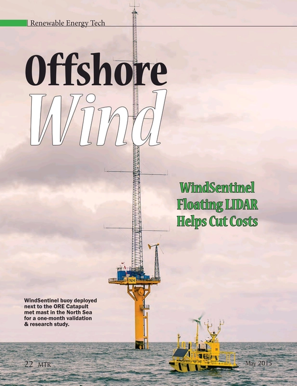
The WindSentinel Floating LiDAR solution developed by AXYS Technologies is a wind resource assessment buoy capable of accurately gathering data on wind speed and wind direction offshore at turbine hub-height and across the blade span. The data enables developers to understand how strong the winds are at the heights of wind turbines, provides a clear picture of how much power can be generated at specific sites, and helps to validate wind predictions from computer models.
WindSentinel – What is it designed to do?
The WindSentinel Floating LiDAR solution developed by AXYS Technologies is a wind resource assessment buoy capable of accurately gathering data on wind speed and wind direction offshore at turbine hub-height and across the blade span. The data enables developers to understand how strong the winds are at the heights of wind turbines, provides a clear picture of how much power can be generated at specific sites, and helps to validate wind predictions from computer models. Meteorological and ocean measurements also help scientists understand air-sea interactions. The WindSentinel facilitates cost effective, accurate monitoring of many key parameters required by offshore wind farm developers to determine if their proposed project will pass financial investment decision (FID) and gain the financial support needed from their project funders.
AXYS equips a 6m NOMAD buoy with relevant sensors such as dual-LIDAR systems, current sensors, wave sensors and is also able to install other sensors required by our clients. To support the WindSentinel, AXYS gives clients access to real-time data through our AXYS-APS portal. AXYS works with clients to understand their measurement campaign data needs so that we can enable early analysis and quality control as soon as data is transmitted.
Value in the Renewable Energy Sector
Prior to wind farm construction, a series of environmental monitoring campaigns are required to understand local wind resource, bird and fish populations and sea states. The current solution to measuring local wind conditions is to install a rather costly meteorological mast (10m Euro) equipped with anemometers and extrapolate those measurements across the length of the wind farm. To measure sea states, wave buoys and weather forecasting models are used. Standards for monitoring bird and fish populations are still being developed, but may include use of observers and sophisticated radar systems. The WindSentinel floating LiDAR eliminates the need to construct a meteorological mast and provides all the required data from a moveable and low environmental-impact buoy. Floating LiDAR decreases the overall cost and time to market of offshore wind developments.
Design Drivers
The WindSentinel was designed to use the proven metocean NOMAD buoy and a LiDAR capable of measuring wind from a floating platform. In selecting the NOMAD hull as the optimal platform, AXYS focused on the following key criteria:
• The hull needed to be well known and reliable
• The hull needed to have the capacity to support the
necessary sensor payload
• The hull needed to be able to support a power supply
which could be deployed for up to a year between services
AXYS has 25 years of experience of working with the NOMAD hull, which has an extensive history as a platform for offshore sensors. The NOMAD hull was originally designed in the 1940s for the US Navy’s offshore data collection program and was later adapted and used by the National Data Buoy Center (NDBC) and Environment Canada as part of the national networks of permanent buoy stations providing weather forecasting.
The WindSentinel was also designed to be flexible enough to accommodate virtually any sensor and telemetry while being easy to modify as project requirements evolve. As part of ongoing improvements to our technology, AXYS has recently begun developing WindSentinel buoys with dual-LiDAR in order to increase total data availability and to reduce the level of risk of data outage during extreme weather conditions often expected during wind assessment campaigns. This redundant dual-LiDAR configuration is the first in the world to be designed and deployed and reflects AXYS’ commitment to fund research & development to further reduce the overall cost of offshore wind development.
Case Studies
AXYS has sold 11 WindSentinels to projects in the United States, Portugal, France, and Taiwan. Here are three case studies that illustrate those projects. Grand Valley State University (GVSU) Michigan Alternative Renewable Energy Center (MAREC) was tasked with the objectives to select and demonstrate the technical viability and economic performance of renewable and alternative energy technologies. Their goal was to implement a comprehensive wind assessment review on Lake Michigan and the project featured LiDAR based extended season wind assessment and related environmental studies. The AXYS WindSentinel was selected and deployed in the fall of 2011 for a three-year study. The study concluded in 2014 and GVSU and its partner scientists learned that the quantity and quality of the Lake Michigan winds are favourable for offshore generation of electricity with commercial wind turbines. On October 30th, 2012, Hurricane Sandy reached the GVSU WindSentinel deployed at the center of Lake Michigan, 36 miles offshore. Sandy produced 26 m/s (58 mph) winds, a gale force storm on the Beaufort Scale, and 10m waves with an average wave period of 8.3 seconds. The WindSentinel recorded wind and Metocean data for the entire event. EDP Inovação (EDPi) under the European funded project, DemoWFloat, deployed a WindSentinel off the coast of Portugal near Viana do Castelo in July 2014. EDPi are using it to test and monitor the performance of their prototype floating wind turbine and contribute for the development of new methodologies for deep offshore resource assessment, and also refine the wind estimate for this location. This WindSentinel survived a major storm that ravaged the coast of Portgual near Viana do Castelo on October 16, 2014. Enduring gale force winds with gusts of over 90 km/hr and waves the size of three-story buildings (10 metres high), the WindSentinel remained on-station, fully operational with 100% data availability.
Pacific Northwest National Laboratory (PNNL) on behalf of the U.S. Department of Energy (DoE) contracted AXYS to supply two WindSentinel floating LiDAR systems. The systems are managed by PNNL to support research and development to help advance the U.S. offshore wind industry. Starting in November 2014, they are deployed for up to a year at two offshore wind demonstration projects: one near Coos Bay, Oregon, and another near Virginia Beach, Virginia.
The buoys carry a multitude of advanced instruments, including LiDAR to measure wind speed and direction at multiple heights above the ocean. Other onboard instruments will record air and sea surface temperature, barometric pressure, relative humidity, wave height and period, and water conductivity. Subsurface ocean currents will also be measured with acoustic Doppler sensors. All of these measurements will help scientists and developers better understand air-sea interactions and their impact on how much wind energy a turbine could capture at particular offshore sites. The data will also help validate the wind predictions derived from computer models, which have thus far relied on extremely limited real-world information.
(As published in the MAY 2015 edition of Marine Technology Reporter - http://www.marinetechnologynews.com/Magazine)
Read WindSentinel Floating LiDAR Helps Cut Costs in Pdf, Flash or Html5 edition of May/Jun 2015 Marine Technology
Other stories from May/Jun 2015 issue
Content
- Grasshopper Rides Falcon for 3D View of Dam page: 8
- Meet the AutoNaut page: 14
- WindSentinel Floating LiDAR Helps Cut Costs page: 22
- AUVs: Getting Defensive page: 28
- Dive into Norway's Subsea Valley page: 38
- d’ROP Bibby’ Hydromap’s Custom-built ROV page: 44
- MacArtney Launches NEXUS MK VII MultiPlexer page: 50
- EvoLogics Launches High-speed Mini-modem page: 50
- New Tracking Tech: Diver6 System page: 51
- Applanix’ Expanded Marine Product Portfolio page: 51
- Kongsberg’s New Marine Motion Sensor page: 51
- Falmouth Scientific’s New Chirp Transceiver page: 52
- Teledyne TSS Launches Powertrack Subsea Cable Tracker page: 52
- Valeport’s SWIFT SVP page: 53
- Dolphin Sea View 2D Sonar page: 53
- Fifth-Generation OCTANS Launched page: 53
- New Sonardyne ‘Syrinx’ Doppler Velocity Log page: 55
- New Software from EIVA page: 55
- Linden Photonics Debuts Hybrid Cables page: 56
- STR Unveils Rechargeable Battery Pack & Charger System page: 56
- New Switchable Magnet Launched as Tool for ROVs page: 57
- New Multibeam Z-Boat page: 59
- Seaperch Underwater Robotic Championships page: 60