
Is it a Ship or Iceberg?
By Andrew Safer
Developing the capability to discriminate between ships and icebergs in northern latitudes is a common interest shared by Canada’s Department of National Defense (DND) and the oil and gas industry. For DND, the focus is on ship detection for maritime security, whereas oil and gas companies are interested in detecting icebergs to ensure primarily the safety and also the productivity of offshore exploration and production operations.
Polar Epsilon
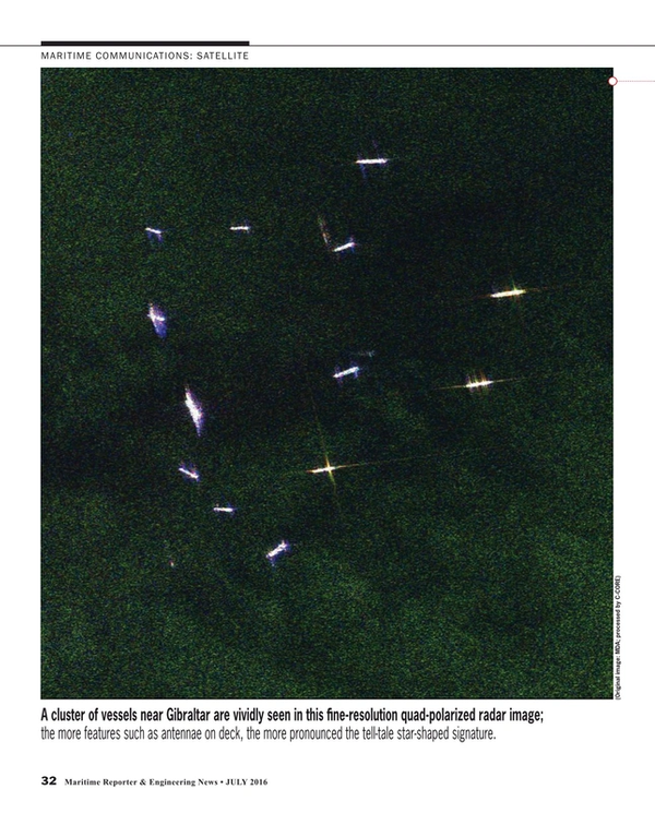
The Polar Epsilon and Polar Epsilon-2 applied R&D projects are focused on improving detection capabilities through the use of synthetic aperture radar (SAR) via RADARSAT-2 and the RADARSAT Constellation Mission (RCM)—three satellites the Canadian Space Agency is scheduled to launch in 2018. A partnership between DND and C-CORE of St. John’s, Newfoundland and Labrador is developing the expertise to use SAR imagery to differentiate between ships and icebergs. “This case clearly demonstrates the synergy that exists between the Canadian government and the oil and gas industry,” notes Desmond Power, vice-president of remote sensing at C-CORE. He explains that a year and a half ago, C-CORE completed a project in which they developed the capability to provide ice charts for the oil and gas industry, which invested $1.2 million in research. Now, C-CORE is developing further expertise in this area to meet DND’s requirements. Power points out that SAR images “are not pretty Google images. They’re funky-looking echoes instead of nice shapes.” He adds that microwave radiation is a long wavelength, which doesn’t reflect back in the same way that the eyes interpret, so it’s not intuitive. Vessels show up in a diamond pattern. Bright rings in the image indicate a large supply vessel. “Our people have the experience to be able to look at images and say ‘That’s an iceberg’,” he says, “and they’re right 90 to 95 percent of the time.”
The Advantage of Cross-Polarization
When the Canadian Space Agency launched RADARSAT-1 in 1995, among its functions was to provide ice monitoring for the Canadian Ice Service and Canadian Coast Guard, but it wasn’t used for surveillance. In 2007 RADARSAT-2 was launched with greater capabilities, not the least of which is cross-polarization. “We noticed that cross-polarization did a much better job differentiating between an iceberg and a ship,” observes Power. Cross-polarization provides the ability to transmit electromagnetic waves in a horizontal electric field orientation and receive them in a vertical electric field orientation, or vice versa, explains Dr. Paris Vachon, Defense Research and Development Canada’s (DRDC’s) scientific and technical advisor to Polar Epsilon-2. Polarized sunglasses provide an example of the benefit of cross polarization. Since reflected light becomes horizontally polarized, sunglasses are vertically polarized to filter out the horizontally polarized light, thereby reducing glare. One of RADARSAT-2’s two channels filters out the glare, and RCM will have additional polarization channels. Whereas RADARSAT-1 produced “blobs” in the imagery, according to Power, the polarization in RADARSAT-2 filters out several different images making it possible to determine that a ship should look one way, and an iceberg another. “It organizes the information,” says Power. “It separates it out so it’s easier for the eye to decipher and interpret.”
Detection and Classification
For the last year and a half, C-CORE has been collecting data off Greenland, Straits of Belle Isle, Grand Banks, and the Labrador Sea, which they have input into computer vision algorithms to simulate the modes of RCM. They are working towards having the ship-iceberg discrimination capability adapted for use with RCM by the time it is launched, at which point the algorithms will be validated and calibrated. The process involves looking at the image, picking out all of the targets, then focusing on individual targets and providing them to the analyst who classifies them. C-CORE will also be using the algorithms to meet the requirements of the oil and gas industry. Polar Epsilon-2, which is focused on readying RADARSAT-2’s discrimination capability for RCM, is a 50/50 co-investment between DRDC, representing Canadian Forces, and C-CORE through a Defense Industrial Research contract. The intellectual property is retained by C-CORE. Each party initially invested $500,000 and an extension added $225,000 for each partner. The project period runs from late 2014 to the end of 2016.
DRDC’s Dr. Vachon explains that the RCM ship detection capability is being designed to detect 90 percent of ships that are 25 metres or longer in up to sea state 5, which appear within RCM’s Synthetic Aperture Radar (SAR) swath. “Compared to coverage with RADARSAT-2,” he says, “RCM with its three satellites will be able to provide more complete coverage of the maritime approaches to Canada on a daily basis.” Once RCM is launched, SAR images will be available that almost completely cover the Grand Banks, for example, every day. Currently it takes nearly three days to achieve that coverage. The cross-polarization available from RADARSAT-2 and RCM, once it launches, reduces backscatter from both the ocean background and the ship target, Dr. Vachon explains. The reduction of backscatter from the ocean background is greater than from the ship. “This can result in the ship target appearing brighter than the background in cross-polarization imagery,” he adds, “which improves the ability to detect the ship.”
Reducing False Alarms
A key objective for the Royal Canadian Navy is to reduce false alarms in ship detection, advises Dr. Vachon who adds that “the challenge is to distinguish ships from icebergs in the wide swath, low spatial resolution modes that will be available from RCM for wide-area maritime surveillance.” Reducing false alarms from the system is a matter of significant interest, he says, because dispatching either an aircraft or ship to the location of the supposed ship only to find an iceberg causes “an undue amount of stress”, both in terms of available resources and cost (an airplane could cost several thousand dollars per hour to operate).
An important region of operational interest, he says, is from Newfoundland and Labrador to the higher latitudes where ships might operate at different times of the year. “It’s no secret that the east coast of Canada is a key area that would benefit from having this type of algorithm available,” Dr. Vachon says, as it would simplify surveillance in that region. If SAR detects an object, that information can then be associated with available AIS data. A match would indicate the presence of a ship that is most likely operating in compliance with regulations, whereas the absence of AIS data would suggest that the opposite might be true, perhaps triggering further investigation.
Polarization and Ice-Infested Waters
Lieutenant-Commander Chad Kabatoff, Department of National Defense (DND), represents the DND operational community who will benefit from the ship-iceberg discrimination algorithms that C-CORE is developing. He differentiates between non-challenging areas where the Canadian Navy’s ship detection capability is currently acceptable, and challenging areas. “Ice-infested waters are very difficult,” he says. “That’s where polarization can help.” He emphasizes the value of global access on a daily basis: “You can’t fly an aircraft to everywhere that RADARSAT-2 has access on a daily basis. The coverage it provides is immense.” Furthermore, space-based systems provide access to areas that would otherwise be inaccessible to Canadian aircraft. Since RADARSAT-2 is always orbiting over the North, images of a particular location can be acquired at least twice a day. He points out that a lot of other sensors are passive and are compliance-based, so if someone is trying to hide and is non-compliant, it would be very difficult to detect them, using any method other than space-based SAR. He adds that icebergs and ships trying to hide would present themselves identically in the imagery. Asked about the collaboration with C-CORE, he said, “C-CORE definitely has a very interesting capability to analyze these problems that require advanced and niche technical knowledge. Having their ability to analyze this problem is immensely useful.
Eye in the Sky Spots Icebergs for Oil and Gas Companies
Tony King, C-CORE’s director of ice engineering, liaises with oil and gas companies that make use of C-CORE’s expertise. Iceberg detection supports long-range planning—up to six months in advance of deployment at a drill site—or shorter-term time frames (days or weeks) in support of ongoing operations. For example, an operator who is planning a project in Baffin Bay would want to know the total iceberg frequency, which would be input into a model that included average circulation patterns and the expected deterioration rate (iceberg melt rate) based on long-term weather forecasts. When RADARSAT-2 and other satellite imagery was used by an oil and gas operator off the Falkland Islands, the objective was to characterize iceberg frequency and the extent of downtimes and input the data into the facility design.
“They see the benefit down there,” King says, “because they don’t have the infrastructure for aerial reconnaissance that is the norm in this part of the world.” Other areas where oil and gas companies have used satellite data include Grand Banks, East and West Greenland, Barents Sea, Beaufort Sea, and Kara Sea. Operationally, King adds, icebergs are more of an issue for an FPSO (floating production storage and offloading facility) than for a GBS (gravity-based structure), even though disconnecting is an option for FPSOs. That said, downtime for a drilling operation can cost several hundred thousand dollars a day. To manage ice risk, Grand Banks operators have a no-contact policy.
If a bergy bit (a piece of glacier ice between 1 and 5 meters above sea level) is detected, depending on distance from the area of interest, it may melt well before approaching the watch circle, so estimating the time to deteriorate is key. King sees satellite data taking a more central role in the Flemish Pass and the newer deepwater Newfoundland and Labrador blocks.
Satellite SAR is very effective for surveilling sizeable areas of the ocean; targets identified in SAR imagery can then be verified by aerial reconnaissance, minimizing unnecessary but costly deployment of aircraft. Desmond Power points to the economic benefit of RADARSAT-2, adding that an oil company engaged C CORE for the first time this year in order to save money. “Satellite monitoring is a way to save money compared sending a vessel out there,” he says. “You can surveil up to 250,000 square kilometers for a couple of thousand dollars.”
In the Arctic, Power continues, increased variability within the seasons is producing anomalous ice environments, which together with increased maritime activity is making ship detection more complex. The technology advances that are being developed through Polar Epsilon-2 to enable increased accuracy in identifying ship and iceberg targets will assist DND in protecting Canada’s Northern waters.
(As published in the July 2016 edition of Maritime Reporter & Engineering News)
Read Is it a Ship or Iceberg? in Pdf, Flash or Html5 edition of July 2016 Maritime Reporter
Other stories from July 2016 issue
Content
- Can Bandwidth Supply Keep up with Maritime Demand? page: 10
- Safety and Preparation on the Brownwater Radar page: 14
- Subchapter M: Slow Walking the Inspection of Towing Vessels page: 16
- Panama Canal: Assessing the Risk & Reward page: 18
- Drones: Is the Maritime Industry Ready? page: 22
- Subsea Cables Protected with Virtual Tech page: 26
- Kongsberg: Blazing a Digital Trail page: 28
- The ‘Paperless’ Ship page: 30
- Is it a Ship or Iceberg? page: 32
- Effective Maritime Instructors: What Are They? page: 46
