Using AIS Data to Assess Collision Risks
Automatic Identification System (AIS) data is now being used to determine the collision risk for offshore installations.
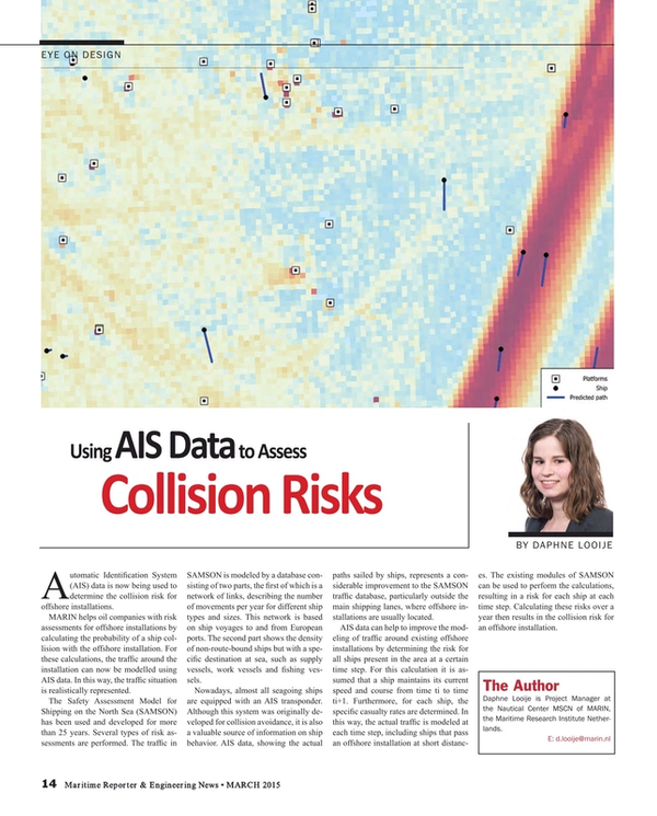
MARIN helps oil companies with risk assessments for offshore installations by calculating the probability of a ship collision with the offshore installation. For these calculations, the traffic around the installation can now be modelled using AIS data. In this way, the traffic situation is realistically represented.
The Safety Assessment Model for Shipping on the North Sea (SAMSON) has been used and developed for more than 25 years. Several types of risk assessments are performed. The traffic in SAMSON is modeled by a database consisting of two parts, the first of which is a network of links, describing the number of movements per year for different ship types and sizes. This network is based on ship voyages to and from European ports. The second part shows the density of non-route-bound ships but with a specific destination at sea, such as supply vessels, work vessels and fishing vessels.
Nowadays, almost all seagoing ships are equipped with an AIS transponder. Although this system was originally developed for collision avoidance, it is also a valuable source of information on ship behavior. AIS data, showing the actual paths sailed by ships, represents a considerable improvement to the SAMSON traffic database, particularly outside the main shipping lanes, where offshore installations are usually located.
AIS data can help to improve the modeling of traffic around existing offshore installations by determining the risk for all ships present in the area at a certain time step. For this calculation it is assumed that a ship maintains its current speed and course from time ti to time ti+1. Furthermore, for each ship, the specific casualty rates are determined. In this way, the actual traffic is modeled at each time step, including ships that pass an offshore installation at short distances. The existing modules of SAMSON can be used to perform the calculations, resulting in a risk for each ship at each time step. Calculating these risks over a year then results in the collision risk for an offshore installation.
The Author
Daphne Looije is Project Manager at the Nautical Center MSCN of MARIN, the Maritime Research Institute Netherlands.
E: [email protected]
(As published in the March 2015 edition of Maritime Reporter & Engineering News - http://magazines.marinelink.com/Magazines/MaritimeReporter)
Read Using AIS Data to Assess Collision Risks in Pdf, Flash or Html5 edition of March 2015 Maritime Reporter
Other stories from March 2015 issue
Content
- Editorial: The MAN in Command page: 6
- Getting Onboard the Regulatory Train page: 8
- Moskito to Recover Oil from Sunken Wrecks page: 10
- Studies Show U.S. Offshore’s Untapped Potential page: 12
- Big Spending on Liquefaction Terminals page: 13
- Using AIS Data to Assess Collision Risks page: 14
- Resilience & the Maritime Industry page: 16
- EALs & Oil Spill Remediation page: 18
- Imtech Marine USA and Radio Holland ‘Reloaded’ page: 20
- Maritime Training Five Years from Now: A Look Ahead page: 22
- Turkey Maritime Sector Alive & Kicking page: 24
- Schmiedag and Wildauer Schmiedewerke: 'We Forge Partnerships' page: 26
- SimCity page: 31
- Maritime Simulation “A-to-Z” page: 38
- USCG Adm. Zukunft: The Man, His Mission page: 40
- USCG Makes Headway in Challenging Waters page: 48
- US Tank Barge Regs Loom, Laborde Presses Mitsubishi’s 'Mechanical Advantage' page: 52
- Coast Guard Foundation Supports USCG Men, Women, Families page: 53
- Marine Salvage & Oil Spill Response Insights page: 54
- Oil Under Ice page: 56
- Greek Fleet (Still) Rules page: 60
- Push Boats: From Turkey to Brazil page: 62
- LNG Barge: Conrad to Build Historic First page: 63
- Light-Off for Pasha’s New ConRo page: 63
- Imabari Invests in Shipbuilding page: 64
- Thunderbolt: Eastern Delivers Innovative Towboat page: 64
- MLP3 AFSB NASSCO Delivers for the Navy page: 65
- How to Approach Maritime Cyber Security page: 66
- Terragon: Next-Step in Ship Waste Handling page: 68


